
By Dr. Dennis Williamson
This blog article is adapted from and contains excerpts from a PhD research thesis completed during late 2017 at Deakin University by Dr. Williamson titled: Australian Wheatbelt Farmers’ and NRM Responses to Ecological Principles, Climate Change, Agricultural Production and Biodiversity Effects at a Landscape Scale.
References are provided at the end for the Author’s article. For references bracketed within quotations from other authors, please refer to their original articles for those references.
© Dennis N. Williamson and Geoscene International (a division of Scenic Spectrums Pty Ltd) 2018. Unauthorized use and/or duplication of this material without express and written permission from this site’s author and/or owner is strictly prohibited. Excerpts and links may be used, provided that full and clear credit is given to Dr. Dennis N. Williamson and Geoscene International (a division of Scenic Spectrums Pty Ltd) with appropriate and specific direction to the original content.
Overview
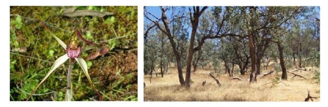
Can you imagine Australia without cassowaries, cockatoos, dingoes, koalas, platypus, or Tasmanian devils? Or without boab, bottlebrush, casuarina, coolibah, ghost gum, mallee, red gum, snow gum or stringybark trees? Or without grass trees, grevillias, kangaroo paws, waratahs, spinifex, or Stuart's desert peas? Or without many of the other iconic and even lesser known flora and fauna species that make this continent one of the most unique places in the world? Figures 1 - 4 provide just a glimpse of some of these species and ecological communities.
Figures 1 and 2 Carnaby’s Black Cockatoo (Calyptorhynchus latirostris)[1] and Honey Possum (Tarsipes rostratus)[2]

Figures 3 and 4 Coloured Spider-orchid (Caladenia colorata) and Box-Gum Grassy Woodlands (including Eucalyptus albens, E. melliodora and/or E. blakely)[3]
These other species are not human, but in many ways they really are an extension of us. They are part of the quintessential Australian landscape and experience. They are deeply imbued in Australian art, music, literature and tourism. To us, they are as much cultural as they are biological. They are part and parcel of what makes Australia 'Australia'.
In recent times, however, a great deal of concern has been expressed by ecologists and environmentally-minded Australians and organisations that we are in danger of losing a high percentage of many Australian native plant and animal species due to the combined effects of habitat fragmentation, climate change and other factors.
There have been outcries for and against changes in legislation that make it easier for private landholders to clear remnant native vegetation. Concerns have also been expressed about inadequately administered and applied environmental legislation, such as Australia's Environmental Protection and Biodiversity Conservation Act 1999, that are intended to protect indigenous species and ecosystems. However, many of the arguments put forward in newspaper and magazine articles and in the social media tend to focus narrowly on the plight of specific species, local areas or regions. They do not always provide the full context of the history of species loss in Australia or the underlying reasons as to why such species and ecosystems are so fragile and precariously balanced at this point in time.
In order to communicate and prosecute the case for better ecological stewardship in Australia, we need to foster a more complete view of the implications at hand for all concerned - the public, landholders, land developers, corporations and politicians. This article focuses on the historical background, the interplay of native vegetation clearing and climate change, and the implications of these threats not only on native species, but on the health of our land, on agricultural productivity and on Australians as a society and individuals.
The article addresses the following topics:
Habitat Fragmentation and Species Loss Concern
Historic Clearing of Native Vegetation
Extent of Past Clearing
Effects of Habitat Fragmentation on Species
Clearing and Climate Effects on Agriculture
Threatened Species and Ecosystems Protection
Climate Change and Species Vulnerability
Inadequacy of the National Reserve System
Conclusion
Habitat Fragmentation and Species Loss Concern
Serious concerns about recent vegetation legislation in the States of New South Wales and Queensland that either reduce the regulation and controls over native tree and vegetation clearing for agricultural purposes (as in NSW) or that tighten such regulations (as in Queensland) have been a hot topic in recent times. In addition, there has also been concern over the lack of listing of critical habitat for threatened species under the EPBC Act 1999. Articles on these topics have appeared in various Australian newspapers (as well as in several posts on Facebook and LinkedIn) addressing these issues specifically[4]. Most of the concerns expressed centre around the themes of “Habitat Fragmentation” and “Species Loss”, or alternatively, infringements on farmers’ rights to manage their own land.
The Australian Government’s Department of Environment and Energy reports that Australia has had the largest documented decline in biodiversity of any continent of the world over the past 200 years[5]. They state that reversing this decline through biodiversity policies and management actions has so far failed and they identify the main threats as:
loss, fragmentation and degradation of habitat;
the spread of invasive species (i.e., feral animal predation);
unsustainable use of natural resources;
climate change;
inappropriate fire regimes; and
changes to the aquatic environment and water flows.
Woirnosky et al.[6] confirms these statements on biodiversity decline, stating that:
“The highly distinctive and mostly endemic Australian land mammal fauna has suffered an extraordinary rate of extinction (>10% of the 273 endemic terrestrial species) over the last ∼200 y: in comparison, only one native land mammal from continental North America became extinct since European settlement. A further 21% of Australian endemic land mammal species are now assessed to be threatened, indicating that the rate of loss (of one to two extinctions per decade) is likely to continue.”
Placing species loss within the global and continental Australian contexts, Barnosky et al.[7] find that:
Current extinction rates are higher than those that caused the ‘Big Five’ extinctions in geologic time. These rates could be severe enough to carry extinction magnitudes to a mass extinction benchmark within as little time as three centuries. However, there are several major unknowns that could affect this projection;
Recent species losses have occurred rapidly and must be taken seriously, but the rates and magnitude have not reached mass extinction levels (i.e., only a few percent of assessed species have been lost in recent history, even though we cannot know the full magnitude of species lost due to inadequate identification and assessments);
In applying conservative methods of estimation, the indications are that losing ‘critically endangered’ species would tip the scales and create a state of mass extinction of a similar level to the previous five mass extinction events due to ‘perfect storm’ conditions caused by “multiple, atypical high-intensity ecological stressors, including rapid, unusual climate change and highly elevated atmospheric CO2”.
Many ecologists believe that rapid changes in climatic conditions will place 20%-50% of the world’s flora and fauna species at risk of extinction or significant population depletion if a mean temperature increase of 2°C above pre-industrial period mean temperatures occurs by 2030, and as high as a 50-60% loss of species by 2100[8].
Regions with the types of biomes found in Australia would risk higher levels of extinctions than other areas of the world[9].
Historic Clearing of Native Vegetation
Fisher and Harris[10] provide a simplified illustration of the historical process of vegetation cover changes in rural Australian landscapes in Figure 5 and state that:
“The fragmentation of previously continuous areas of native vegetation is a major step on the downward spiral to an unsustainable landscape and has serious consequences for biodiversity.”
Figure 5 Landscape Degradation Process Over Time[11]

Over only the first 200 years of European settlement in Australia, clearing of forests and woodlands for agricultural grazing and cropping left the nation with forest cover that was equivalent to that found in northern hemisphere regions that had been farmed extensively for thousands of years[12].
Barson et. al.[13] estimated that:
For the period from 1983 to 1993, over 600 000 ha per year of native vegetation (including regrowth) was cleared in Australia;
For the period from 1991 through 1995, 1,786,440 ha of woody land cover was lost, including:
- 64 percent (1,142,960 ha) for agriculture (cropping) and grazing;
- 23 percent (410,881 ha) due to fire;
- 9 percent (161,050 ha) due to harvesting of plantations and native forests; and
- 4 percent (71,458 ha) due to other activities (primarily urban and infrastructure development).
The Barson report shows that clearing from 1991 – 1995 accounted for more than 50% of the total land cover change and 77% of the clearing that contributed to greenhouse gas emissions in the land use change sector of the National Greenhouse Gas Inventory during that period.
The CSIRO’s 2014 report[14] on biodiversity indicates that:
since European settlement in the late 1700s, clearing of native vegetation has been the most extensive along:
- the coastal zones adjacent to cities;
- in the Murray-Darling Basin; and
- and in the Western Australian wheatbelt.
only remnants of the grassy woodlands of eastern Australia remain and the southern eucalyptus woodlands have been most greatly affected.
Extent of Clearing
Bradshaw[15] has highlighted the significance of native forest and woody vegetation clearing:
“Overall, Australia has lost nearly 40% of its forests, but much of the remaining native vegetation is highly fragmented. As European colonists expanded in the late 18th and the early 19th centuries, deforestation occurred mainly on the most fertile soils nearest to the coast. In the 1950s, southwestern Western Australia was largely cleared for wheat production, subsequently leading to its designation as a Global Biodiversity Hotspot given its high number of endemic plant species and rapid clearing rates. Since the 1970s, the greatest rates of forest clearance have been in southeastern Queensland and northern New South Wales, although Victoria is the most cleared state.”
”South Australia’s forests were also mostly cleared during the 19th and early 20th centuries (Szabo et al. 2011), where in some regions such as the Mount Lofty Ranges close to the state’s primary urban centre (Adelaide) only 10% of woodlands remained when broadscale clearing largely ceased in 1980 (Paton and O’Connor 2009) …. Native forests are now estimated to cover only 9% of the state’s total area (Australian Bureau of Rural Sciences, 2010).”
“The 140 000-km2 area of southwest Western Australia that contains the Biodiversity Hotspot and now known as the ‘wheatbelt’ consisted mainly of a complex mosaic of salmon (E. salmonophloia), York (Eucalyptus loxophleba) and wandoo (Eucalyptus wandoo) woodlands, heath thickets and scrub (Saunders 1989). But by 1968, over 130 000 km2 of that area had been cleared (Saunders 1989). And the clearing continued well into the late 1980s—the state government approved applications to clear between 30 000 and 60 000 ha /year during that decade (Schur 1990). In some parts, the devastation is near total. For example, in the central part of the wheatbelt (the Avon Botanical District), over 93% of the original vegetation was cleared, with up to 97% of woodlands removed (Saunders 1989). In another 1680-km2 area near Kellerberrin, 93% of the vegetation had been removed since 1940 (Saunders et al. 1993).”
“According to the Victorian Government, 66% of the state’s native vegetation has been cleared since European colonization. (Victoria Department of Sustainability and Environment 2011), leaving 34% of the state’s land area covered by native forests (7 837 000 ha) Australian Bureau of Rural Sciences 2010). According to Lindenmayer (2007), this makes Victoria the most heavily cleared state in the country. Most of the clearance occurred prior to the 1890s as the wheat and livestock industries expanded with European colonization; thereafter, clearance continued at a relatively stable rate of 1% per year until 1987 when stringent anti-clearing legislation was introduced (Lindenmayer 2007). However, even from 1995 to 2005, proportional clearance rates remained high and even increased in the latter part of that decade to become the highest among all states and territories in 2005.”
Figures 6 and 7 provide two visual examples of the extent of clearing in NSW and Western Australia. Similar patterns exist across Australian agricultural regions, particularly in Wheatbelt regions[16]
Figure 6 Extent of Woodland Clearing in Northern NSW: 1985 vs. 2000[17]

Figure 7 Percentage of Eucalypt Woodlands Cleared in the Western Australian Wheatbelt Region[18]

Effects of Habitat Fragmentation on Species
In a landscape ecology context, there is broad agreement[19] that land use modification and fragmentation have negative effects on:
ecosystem functioning and community structure;
habitat quantity and quality in relation to edge effects, patch areas, patch shape complexity, connectivity or isolation of habitats;
the structure and heterogeneity of modified areas; and
the degree of contrast of remaining habitat patches with the surrounding landscape matrix.
Fischer and Lindenmayer’s suggested relationships between the various threatening processes and species biological ameliorating attributes are as outlined in Table 1.
Table 1 Key Threatening Processes and Ameliorating Biological Attributes[20]

The Western Australian experience demonstrates the importance of remnant native vegetation cover on private lands and the effect of habitat fragmentation on habitat condition and quality. The Department of Environment and Energy’s Threatened Species Scientific Committee[21] reports that following a 71% decline in total vegetation cover from the pre-European extent, the proportion of the remaining native vegetation for the region on private land is 37.5%, with 8.5% on leasehold properties. The balance of remnant vegetation is contained on WA Parks and Wildlife (Dept. of Biodiversity, Conservation and Assets) managed conservation reserves or on other public lands (including road reserves).
The Threatened Species Scientific Committee sums up its recommendations on page 40 of the report, saying:
“The Committee considers that the change in integrity experienced by the ecological community is very severe and regeneration across the extent of the ecological community is unlikely in the immediate future. Therefore, the ecological community is eligible for listing as critically endangered under this criterion.”
The fragmentation levels of the remaining native vegetation in the WA Wheatbelt Woodland are shown according to the number of patches in four different categories of size in Table 2.
Table 2 Fragmentation Thresholds of Wheatbelt Woodlands Remnant Native Vegetation Patches by Size, Number and % of Total Area[22]

The Committee’s report notes that 89% of the remaining remnants consist of 12 dominant vegetation associations of which 93.5% are in patches of ten hectares or less, and two-thirds of those are patches of 1 ha or less. Current median patch sizes of 0.48 ha compare to pre-1750 estimated median patch sizes of 150 ha.
The Committee’s report included an assessment of bushland condition as assessed by the WA Department of Parks and Wildlife for remnants that had been registered for the Land for Wildlife program. The relative percentage of each size category of the remnants assessed as excellent, good or poor-moderate. This data is shown in Figure 8, reflecting how the quality of remnant vegetation for habitat markedly decreases as the patch becomes smaller.
It is important that the issues surrounding the listing of the Wheatbelt Woodlands on the EPBC Act’s listing of threatened species are not limited to habitat loss and species distinction.
Figure 8 Bushland Condition of WA Wheatbelt Native Vegetation Remnants Registered with the Land for Wildlife Program[23]

Clearing and Climate Effects on Agriculture
The extensive clearing of native vegetation cover around the wheatbelt region resulted in other problems that were adversely affecting farmers more than flora and fauna issues, including:
chemical fertilizer applications – having a further adverse effect on native species not adapted to higher nutrient loads created artificially;
the introduction and facilitation of weed invasions due to the disturbance of ground covers and soils, the addition of fertilizers, and grazing;
grazing by livestock – add more nutrient enrichment to the topsoils; spread of weeds into patches; trampling, compaction and degradation of soils, which can lead to loss of vegetative cover and, in some cases, erosion of soils;
altered hydrologic regimes in which the flows and quality of water are shifted out of their natural patterns. Farmers replaced perennial deep-rooted plants with grain crops that are shallow rooted, leading to Approved Conservation Advice (including listing advice) for higher water tables, an increase in waterlogged land and increased surface runoff volumes, changing the habitat suitability for many of the existing native flora and fauna. A second and more pervasive effect of the altered hydrology is that of salinisation, as the natural water table rises through salt deposits in the deeper soil horizons, leaving that salt in the upper soil profile as the water evaporates. Lastly, this process may also lead to the local soil to become acidified; and
Salinity has become a major problem in the WA wheatbelt, affecting a total of 54.6% of farms in the region. In extreme cases, the soils had become so contaminated that farming need to cease or become less productive.
Tree clearing has also been associated as a causal factor in reduced precipitation. In a 2013 study by Andrich and Imberger[24], they compare Western Australian coastal and inland rainfall to show empirically that 55% to 62% of the observed rainfall decline is the result of land clearing alone. The reduced precipitation and rising temperatures associated with climate change are also cited as the cause of a drop in Australian wheat yields/ha by 27% from 1990 to 2015 is attributed to rising temperatures and significant falls in annual precipitation levels[25]. Ironically, agricultural land use and related vegetative clearing accounts for 21% of global greenhouse gas (GHG) emissions driving adverse climatic effects[26] and about 33% of Australia’s GHG emissions[27].
Threatened Species and Ecosystems Protection
Australia’s National Reserve System Task Group (NRSTG)[28] state that reserves under various tenures that cover approximately 13% of the continent and has a national target to:
protect 80% of all regional ecosystems in each IBRA[29] region and subregion by the year 2025; and
protect core areas to protect all threatened ecosystems and species, as well as to provide refugia for species against the effects of climate change by 2030.
The NRSTG believe that by protecting more ecosystems sooner, the prospect for more species adapting to and surviving climate change will increase. Again, the strategy emphasises the need for the protection of ecosystems and species beyond the borders of public reserves, incorporating the broader landscape.
Climate Change and Species Vulnerability
In the Australia 21 report[30], a broad statement on climate change is made:
“Climate change is expected to have profound effects on the land environment, particularly on native vegetation and production systems. Some native vegetation communities are likely to disappear, others will change substantially in extent and composition, and novel ecosystems will arise. Impacts on production systems are likely to be mixed, but generally adverse.”
Although a 1.5°C and 2°C increase in average surface temperatures may sound like a relatively minor change that humans and other organisms should be able to cope with to, Miller[31] stresses that:
“Organisms maximize their fitness at an ‘optimal’ environmental range and can survive only short periods in environmental conditions that exceed a threshold in their ‘critical tolerance limits’."
In a presentation to the NCCARF 2013 Conference, VanDerWal[32] stressed that many faunal species are likely to reach their critical tolerance limits when temperatures exceed two standard deviations of change in temperature within their physiological performance curves. This is likely to happen if mean temperatures rise by 2.3oC or greater. As discussed above, the BOM and CSIRO report[33] shows that very warm months in Australia now create two standard deviations in temperature increase from the mean 11% of the time without reaching an average temperature increase of 2.3oC, as VanDerWal suggests. The frequency of this two standard deviation change has increased by 9% from nearly 40 years ago.
In the examples below, even short periods of such temperature changes could have an adverse impact on some fauna species. The following examples indicate the types of effects such temperature change could have on Australian fauna:
Miller[34] states that:
“In 2010, a two-week heat wave in Western Australia led to the mass death of thousands of birds, primarily budgerigars, as temperatures topped 45 °C — temperatures that exceeded the critical thermal limits of these birds. Because of the importance for mammals of evaporative cooling, it is predicted that the increases in temperature and humidity that might accompany global warming could preclude the existence of mammals, including humans, at many low latitude sites within the next few centuries (Sherwood & Huber 2010)”
Garnett, et. al.[35] found that:
“In the first continental analysis of the effects of climate change on a faunal group, we classified 396 Australian bird taxa as being very highly exposed, sensitive or both. Of these 42 Australian terrestrial and inland water bird taxa are likely to have <10% of their current climate space remaining by 2085, 12 marine taxa have breeding sites that are predicted to be 10% less productive than today, and 61 terrestrial taxa are likely to be exposed to more frequent or intense fires.”
Van DerWal et. al.[36] state that:
“Freshwater ecosystems have very high biodiversity relative to their areal extent. They are particularly vulnerable to climate change because of their limited extent, their limited connectivity and, in much of Australia, their susceptibility to drying resulting from the high variability of temperature and rainfall…. many regions and freshwater biophysical features will experience climates well outside their current range of variability and thus there will be significant changes in assemblages. Within unstable areas refugia will be a high priority, for example areas where temperatures are ameliorated through shading from vegetation or topographic shading.”
For additional information regarding the physiological limitations and bioindicators of fauna in relation to temperature increases and climate change, see articles by Frapell and Daniels[37], and Holt and Miller[38].
Inadequacy of the National Reserve System to Provide Climate Change Refugia
The NRSTG realise that climate change will make it difficult for them to provide habitat for all ecosystems and species within the reserve system. They advocate working with private land and other natural resource managers to adapt to climate change impacts. The NRSTG want to integrate the National Reserve System (NRS) with other habitat protection programs and activities to conserve ecological processes at the landscape scale. Fitzsimons and Wescott[39] had stated several years prior to this that:
“strict reservation alone will not conserve all, or even most, biodiversity within a region. The coordinated management of all land classes and tenures at a landscape scale and implementation of effective ‘off-reserve’ conservation measures are needed to ensure the effective conservation of species, communities and ecosystems.”
In most regions, climate change refugia provided to indigenous flora and fauna is inadequate without additional habitat and connectivity provided within rural road reserves, stream reserves and on private farmlands.
In a national analysis of potential climate change refugia, Reside et. al.[40] found that the southern and eastern regions of Australia fail to provide significant refuge areas for the future protection of biodiversity. These regions, which include much of the wheatbelt, have largely left a legacy of small to very small protected areas. Nationally, Reside et. al.[41] found that:
“…only 14% of refugia identified by our analyses fall within the current protected areas …. For better quality refugia — those ranked four and above — less than 1% exist within protected areas. No area ranked with the highest refugia score fell within a protected area. Interestingly, only 17% of the current protected areas have no refugia value.”
Conclusion
The above discussion underscores the importance of protecting, maintaining and restoring native vegetation cover and ecological habitats across Australia, particularly on private lands outside existing conservation reserves. If we don’t do so, we are apt to lose a high percentage of the indigenous flora and fauna that give Australia its special character.
This is the background to why vegetation clearing and habitat fragmentation are of such great concern.
Further blogs and journal articles by Dr. Williamson will address:
the need for a more rapid response landscape-scale and pattern-oriented approach to habitat fragmentation and climate change impacts; and
a set of simplified key ecological principles drawn from the ecological literature that can be understood and applied by rural landholders while maintaining agricultural productivity and enhancing environmental services to themselves and the broader community.
References
[1] Source: The Echo NetDaily, 2013. Outlook bleak for Carnaby’s black cockatoo. Article (7 November). Online. Weblink: http://www.echo.net.au/2013/11/outlook-bleak-for-carnabys-black-cockatoo/ (Accessed 15 February, 2017).
[2] Source: Adlaya, 2013. “Honey Possum (Tarsipes rostratus) photo.” In: Our Wild World Blog. Online. Weblink: https://adlayasanimals.wordpress.com/2013/08/07/honey-possum-tarsipes-rostratus/ (Accessed 15 February, 2017).
[3] Sources:
Department of Natural Resources, 2015. Native plant - Coloured spider-orchid. Fact Sheet, Nationally endangered, Threatened flora of the South Australian Murray-Darling Basin. Adelaide: Government of South Australia, 2 pp. [Online. Weblink: http://www.naturalresources.sa.gov.au/samurraydarlingbasin/publications/native-plant-coloured_spider-orchid (Accessed 15 April, 2017)].
Source: Northeast Catchment Management Authority, 2017. Threatened Grassy Woodlands Project. Photo by Matt Looby, Department of Sustainability and Environment. Weblink: http://www.necma.vic.gov.au/About-Us/Programs-Initiatives/Threatened-Grassy-Woodlands-Project (Accessed 20 April, 2017)
[4] Refer to :
Slezak, Michael, 2018. 'Global deforestation hotspot': 3m hectares of Australian forest to be lost in 15 years in The Guardian, 5 March, 2018: https://www.theguardian.com/environment/2018/mar/05/global-deforestation-hotspot-3m-hectares-of-australian-forest-to-be-lost-in-15-years (Accessed 8 March 2018).
Cox, Lisa, 2018. Australia has 1,800 threatened species but has not listed critical habitat in 10 years in The Guardian, 6 March 2018: https://www.theguardian.com/environment/2018/mar/06/australia-has-1800-threatened-species-but-has-not-listed-critical-habitat-in-10-years (Accessed 8 March 2018) NSW Government, 2017. State Environmental Planning Policy (Vegetation in Non-Rural Areas) 2017. Weblink: https://www.legislation.nsw.gov.au/#/view/EPI/2017/454/full (Accessed 16 March 2018).
Phelps, Mark and Lucy Kinbacher, 2018. “Palaszczuk delivers new anti-farmer vegetation laws” in Queensland Country Life, 8 March 2018. Weblink: http://www.queenslandcountrylife.com.au/story/5273918/vegetation-palaszczuk-belts-farmers-with-new-tree-laws/ (Accessed 16 March 2018).
Hannam, Peter, 2018. “Bungled': NSW new land-clearing laws deemed invalid by court” in the Sydney Morning Herald, 9 March 2018. Weblink: https://www.smh.com.au/environment/conservation/bungled-nsw-new-land-clearing-laws-deemed-invalid-by-court-20180309-p4z3lf.html (Accessed 16 March 2018).
Salam, Carolyn, 2018. “Vegetation clearing changes back on the agenda, with retrospective effect” in LinkedIn, 13 March 2018. Weblink: https://www.linkedin.com/pulse/vegetation-clearing-changes-back-agenda-retrospective-carolyn-salam Note: Salam’s article is in reference to: The Vegetation Management and Other Legislation Amendment Bill 2018(VMOLA Bill) was introduced into Queensland Parliament on 8 Marc(Accessed 16 March 2018).
[5] Department of Environment and Energy, 2017. Canberra: Australian Government. Online. Weblink: http://www.environment.gov.au/topics/biodiversity/biodiversity-conservation (Accessed 7 April 2017).
[6] Woinarski, John C. Z., Andrew A. Burbidge, and Peter L. Harrison, 2015. “Ongoing unraveling of a continental fauna: Decline and extinction of Australian mammals since European settlement”. In Proceedings of the National Academy of Sciences of the U.S.A., Washington D.C.: PNAS, p. 1.
[7] Barnosky, Anthony D., Matzke, Nicholas, Tomiya, Susumu, Wogan, Guinevere O. U, Swartz, Brian, Quental, Tiago B., Marshall, Charles, McGuire, Jenny L, Lindsey, Emily L., Maguire, Kaitlin C., Ferrer, Ben Mersey, and Elizabeth A. Ferrer, 2011. “Has the Earth’s sixth mass extinction already arrived?” Review Nature. 471 (7336): 9–11.
[8] Refer to:
Cooper, Catherine, and Fran Dorey, 2015. What Are the Impacts of Climate Change? Online. Canberra: Australian Museum. Online. Weblink: http://australianmuseum.net.au/what-are-the-impacts-of-climate-change, (Accessed 29 November 2016).
Maclean, Ilya M. D., and Robert J. Wilson, 2011. “Recent ecological responses to climate change support predictions of high extinction risk.” In Proceedings of the National Academy of Sciences USA, 108 (30):12337–12342.
[9] Thomas, Chris D., Alison Cameron, Rhys E. Green, Michel Bakkenes, Linda. Beaumont, Yvonne C. Collingham, Barend F. N. Erasmus, Marinez Ferreira de Siqueira, Alan Grainger, Lee Hannah, Lesley Hughes, Brian Huntley, Albert S. van Jaarsveld, Guy F. Midgley, Lera Miles, Miguel A. Ortega-Huerta, A. Townsend Peterson, Oliver L. Phillips, and Stephen E. Williams, 2004. “Extinction Risk of Climate Change.” Letters to Nature. Nature, 427(8): 145-148
[10] Fisher A.M., and S.J. Harris, 1999. “The dynamics of tree cover change in a rural Australian landscape”. Landscape and Urban Planning 45:193-207
[11] Source: Fisher A.M, and S.J. Harris, 1999. “The dynamics of tree cover change in a rural Australian landscape”. Landscape and Urban Planning 45: 203.
[12] Angelstram, P., and G.W. Arnold, 1993. “Contrasting roles of remnants in old and newly impacted landscapes: lessons for ecosystem reconstruction.” In: Nature Conservation 3: Reconstruction of Fragmented Landscapes, edited by Saunders, D.A., R.J. Hobbs, and P.R. Ehrlich, P.R., Chipping Norton, New South Wales: Surrey Beatty & Sons, pp. 109 - 125.
[13] Barson, M. M., L. A. Randall, and V. Bordas, 2000. Land Cover Change in Australia. Results of the collaborative Bureau of Rural Sciences - State agencies’ Project on Remote Sensing of Land Cover Change. Canberra: Bureau of Rural Sciences, 92 pp.
[14] Morton, Steve, Andy Sheppard, and Mark Lonsdale (eds.), 2014. Biodiversity: science and solutions for Australia. Collingwood, Victoria: CSIRO Publishing, pp. 39-40.
[15] Bradshaw, Corey J.A., 2012. “Little left to lose: deforestation and forest degradation in Australia since European colonization.” Journal of Plant Ecology 5 (1): 109–120.
[16] Australian Government Department of Sustainability, Environment, Water, Population and Communities, 2011. Australia State of the Environment Report 2011. Online. Weblink: http://www.environment.gov.au/soe/2011/index.html (Accessed 30 November 2016)
[17] Source: Cox, Stephen J., Dominic P. Sivertsen, and Michael Bedward, 2001. “Clearing of native woody vegetation in the New South Wales northern wheatbelt: extent, rate of loss and implications for biodiversity conservation.” Cunninghamia 7(1): 115-116 (Figures 7 and 9).
[18] Source: Department of Environment and Energy, 2015. “Appendix C: Description of Key Threats, Environment Protection and Biodiversity Conservation Act 1999 (EPBC Act).” In: Approved Conservation Advice (including listing advice) for the Eucalypt Woodlands of the Western Australian Wheatbelt. Canberra: Australian Government Data collated by DPaW (2013), p. A48 (Figure C2).
[19] Refer to:
Didham, Raphael K., 2010. “Ecological Consequences of Habitat Fragmentation.” In: Encyclopedia of Life Sciences (ELS). Chichester: John Wiley & Sons, Ltd, pp. 1-11.
Fischer, Joern and David B. Lindenmayer, 2007. “Landscape modification and habitat fragmentation: a synthesis.” Global Ecology and Biogeography 16:265-280.
[20] Source: Fischer, Joern and David B. Lindenmayer, 2007. “Landscape modification and habitat fragmentation: a synthesis.” Global Ecology and Biogeography 16:270.
[21] Department of Environment and Energy, 2015. “Appendix C: Description of Key Threats, Environment Protection and Biodiversity Conservation Act 1999 (EPBC Act).” In: Approved Conservation Advice (including listing advice) for the Eucalypt Woodlands of the Western Australian Wheatbelt prepared by the Threatened Species Scientific Committee. Canberra: Australian Government Data collated by DPaW (2013), p. A48 (Figure C2).
[22] Source: Department of Environment and Energy, 2015. Appendix C: Description of Key Threats, Environment Protection and Biodiversity Conservation Act 1999 (EPBC Act) Approved Conservation Advice (including listing advice) for the Eucalypt Woodlands of the Western Australian Wheatbelt. Canberra: Australian Government Data collated by DPaW (2013). Appendix D: Detailed Assessment of Eligibility for Listing Against the EPBC Act Criteria. (Data from the National Vegetation Information System, supplied by WA DPaW).
[23] Department of Environment and Energy, 2015. “Appendix D: Detailed Assessment of Eligibility for Listing Against the EPBC Act Criteria.” In: Approved Conservation Advice (including listing advice) for the Eucalypt Woodlands of the Western Australian Wheatbelt. Canberra: Australian Government, pp. A59 – A80. [Data supplied by the WA Department of Parks and Wildlife on native vegetation patches registered in the Land for Wildlife Program in the Avon Wheatbelt and Western Mallee regions, as at March 2015. Based on 671 sites with woodland vegetation and/or one of the key eucalypt species present as a dominant species within the site, plus an assessment of bushland quality].
[24] Andrich, Mark A. and Jörg Imberger, 2013. “The effect of land clearing on rainfall and fresh water resources in Western Australia: A multi-functional sustainability analysis” in International Journal of Sustainable Development & World Ecology. Vol. 20 (2013): 549-563.
[25] Hochman, Zvi, David L. Gobbett, and Heidi Horan, 2017. “Climate trends account for stalled wheat yields in Australia since 1990.” Global Change Biology 23 (5): 2071 – 2081.
[26] Environment Reports, Food Matters website: http://www.environmentreports.com/how-does-agriculture-change/ (Accessed 9 October, 2016). [Article references: Tubiello, F. N., M. Salvatore, A.F. Ferrara, J. House, S. Federici, S. Rossi, R. Biancalani, R.D. Condor Golec, H. Jacobs, A. Flammini, P. Prosperi, P. Cardenas-Galindo, J. Schmidhuber, M.J. Sanz Sanchez, N. Srivastava, and P. Smith, P., 2015. “The Contribution of Agriculture, Forestry and other Land Use activities to Global Warming, 1990–2012.” Global Change Biology 21(7): 2655–2660.]
[27] Beyond Zero Emissions, 2014. Zero Carbon Australia Land Use: Agriculture and Forestry Discussion Paper. Melbourne: Melbourne Sustainable Society Institute, The University of Melbourne, pp. 42-53.
[28] National Reserve System Task Group, 2009. Australia’s Strategy for the National Reserve System 2009–2030. Endorsed by the Natural Resource Management Ministerial Council. Canberra: Australian Government, 74 pp.
[29] Note: IBRA - Interim Biogeographic Regionalisation for Australia. Weblink: http://www.environment.gov.au/land/nrs/science/ibra/ibra7-codes (Accessed 20 April, 2017).
[30] Eckersley, Richard, 2013. Repairing and preparing Australia’s landscapes for global change: Why we must do much more. Canberra: Australia21 Ltd., 32 pp.
[31] Miller, N.A., and J.H. Stillman, 2012. “Physiological Optima and Critical Limits.” Nature Education Knowledge 3(10):1.
[32] VanDerWal, Jeremy, Cassandra James, Doug Ward, Samantha Capon, and Lauren Hodgeson, 2013. “Identifying Climate Change refugia for freshwater biodiversity across Australia.” Abstract - Presentation at the NCCARF Climate Adaptation 2013 Knowledge+Partnerships Conference, Sydney, NSW, June.
[33] Australian Bureau of Meteorology, and CSIRO, 2016. State of the Climate 2016. Canberra: Australian Government, p. 5.
[34] Miller, N.A., and J.H. Stillman, 2012. “Physiological Optima and Critical Limits.” Nature Education Knowledge 3(10):1.
[35] Garnett, Stephen, Don Franklin, Glenn Ehmke, Jeremy VanDerWal, 2013. “Climate change and Australian birds - adaptation for the next half century.” Abstract - Presentation at the NCCARF Climate Adaptation 2013 Knowledge+Partnerships Conference, Sydney, NSW, June.
[36] VanDerWal, Jeremy, Cassandra James, Doug Ward, Samantha Capon, and Lauren Hodgeson, 2013. “Identifying Climate Change refugia for freshwater biodiversity across Australia.” Abstract - Presentation at the NCCARF Climate Adaptation 2013 Knowledge+Partnerships Conference, Sydney, NSW, June.
[37] Frappell, P.B., and C.B. Daniels, 1991. “Temperature effects on ventilation and metabolism in the lizard, Ctenophorus nuchalis.” Respiration Physiology 86(2):257-70.
[38] Holt, E.A., and S. W. Miller, 2010. Bioindicators: Using Organisms to Measure Environmental Impacts. Nature Education Knowledge 3(10):8.
[39] Fitzsimmons, James, and Geoffrey Wescott, 2001. “The Role and Contribution of Private Land in Victoria to Biodiversity Conservation and the Protected Area System.” Australian Journal of Environmental Management 8 (3):1.
[40] Reside, A.E., J. VanDerWal, B. L. Phillips, L. P. Shoo, D.F. Rosauer, B. J. Anderson, J. A. Welbergen, C. Moritz, S. Ferrier, T. D. Harwood, K.J. Williams, B. Mackey, S. Hugh, Y. M. Williams, and S. E. Williams, 2013. Climate change refugia for terrestrial biodiversity: Defining areas that promote species persistence and ecosystem resilience in the face of global climate change. Gold Coast: National Climate Change Adaptation Research Facility, 216 pp.
[41] Reside, A.E., et. al. 2013. ibid, p.45.